

Apr 2022
M&M Ag Consulting
Translating Ag Data to Profitability
"Every management decision has to make financial sense; Agworld makes it easy for us to determine this and show us what we should be aiming for."
Ryan Moore
With PCT Agcloud + Agworld, you can seamlessly bring all your precision-ag data: soil, yield, elevation, EM, planting and management-zone layers, into Agworld maps. This integration puts field variability, historic yields and soil data at your fingertips, making scouting, recommendations and decision-making easier and more data-driven.
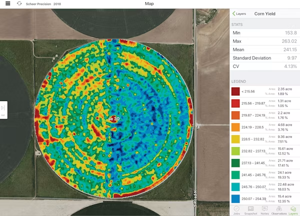
Once your PCT and Agworld accounts are linked, all precision data layers: soil, EM, yield, planting, and more, sync automatically into your Agworld account.
You can view these layers on the Agworld web or mobile app (including offline), annotate them, highlight zones of interest, and attach maps to jobs. This turns raw precision data into actionable insights directly in the platform where you plan, record and manage field work.
How do I set up my Agworld – PCT Agcloud integration?
Sign into PCT Agcloud and navigate to the integrations section to connect with your Agworld account. Once connected, PCT’s data layers linked to your fields will be available inside Agworld for viewing, annotation and attachment to jobs.
What data from PCT Agcloud will I see in Agworld?
Precision-ag layers such as:
You’ll be able to view the layers, annotate them, and attach them to jobs or recommendations inside Agworld.
What subscription level do I need?
You need either the “Agronomist Professional” or “Enterprise” subscription in Agworld to enable the integration. Once linked, growers connected to your account will also see the imported precision layers.
Can the layers be toggled on or off?
Yes — visibility of PCT layers in Agworld can be toggled on or off at any time, giving you control over what data to show.
What are the main benefits of using PCT + Agworld together?
Benefits include:
Use precision data to make smarter agronomic decisions, with less hassle.
With yield, soil and EM layers all in Agworld, you can quickly spot problem areas or opportunities across your farm.
Past yield maps and soil layers help you design better input strategies, rotations, or variable-rate applications.
Agworld’s mobile app supports offline access, so you can view precision data when you’re on the tractor, in paddocks, or anywhere remote.
Send annotated maps or attach layers to jobs/recommendations — all within Agworld — so everyone works from the same accurate data.
M&M Ag Consulting
Translating Ag Data to Profitability
"Every management decision has to make financial sense; Agworld makes it easy for us to determine this and show us what we should be aiming for."
Ryan Moore

Agworld
We are transforming farming into a seamlessly connected ecosystem, where every decision is informed by shared data, collaboration is effortless, and operational clarity drives long-term success.