Bringing field boundaries into Agworld is often one of the first steps in getting up and running with the system. But, whether you’re just starting to use Agworld, importing updated field information, or already managing hundreds of boundaries across your operation, this process needs to be fast, accurate and repeatable.
That’s why we’ve introduced a series of improvements to the Field Boundary Import tool. While the overall workflow remains familiar, you’ll now benefit from enhanced review screens, smarter validation, reusable mapping preferences and support for importing more field information
Together, these updates make importing field boundaries faster, more reliable and less repetitive.
Review your data before you import
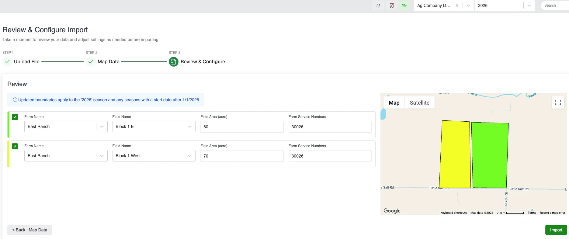
One of the biggest improvements is greater visibility throughout the import process. Before any changes are applied, Agworld now provides enhanced review screens that let you inspect the data being imported and confirm everything looks correct. Rather than discovering issues after the data is in Agworld, you can validate it before making changes.
Additional validation checks also help users identify potential issues during the import process, reducing errors and minimizing the need for manual corrections later. Whether you’re importing a handful of fields or hundreds at once, these improvements provide greater confidence that your farms and fields are set up correctly before you begin entering data for the season.
Save time with smarter mapping
If you regularly import boundaries from Shapefiles or KML files, you’ll notice another significant improvement. Agworld can now remember your previous field mappings and automatically suggest them the next time you import data from the same source. Instead of repeatedly matching the same attributes during every import, previously used mappings can be reused wherever possible, dramatically reducing setup time for recurring imports.
For businesses who service multiple growers or regularly update field data, this makes the import process more efficient.
Import more field information in a single step
Field boundary imports now support a much broader range of field attributes, allowing more of your data to be imported in one streamlined workflow. In addition to field boundaries themselves, you can now import information including:
- Crop and variety
- Crop use
- Field groups
- Field descriptions
- Irrigation details
- Planting information
- Row Spacing
- MTRS attributes
- Licence information
FSA information, including Farm Service Number (FSN), Tract Number and Common Land Unit (CLU) Once imported, these attributes are automatically associated with the field boundary and displayed within the boundary details on the maps page, reducing the amount of manual setup required after import. By bringing more information into Agworld from the outset, you can get fields configured and ready for the season much faster.
Import more field information in a single step
These enhancements are designed to simplify one of the most common administrative tasks in Agworld. With improved review capabilities, extra validation, repeatable mapping preferences and expanded attributes, importing field boundaries is now quicker, more accurate and easier to manage than ever before.
Whether you’re a new customer, updating existing field boundaries or preparing for the season ahead, the enhanced Field Boundary Import tool helps you spend less time manually adding data and more time getting value from it.
For a step-by-step guide on these new features, click here to access the Agworld help centre.